People in Bahrain are being urged to take steps to protect themselves from a potential ‘heat dome’ that could form sometime next week, resulting in dangerous temperatures.
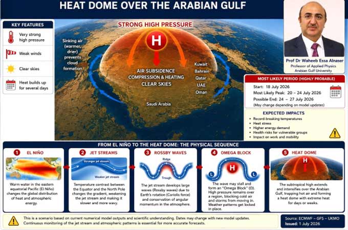
Arabian Gulf University professor of applied physics Dr Waheeb Alnaser said in a Gulf Daily News report that the phenomenon could occur during the second half of this month if subtropical atmospheric pressure continues to strengthen over the Arabian Peninsula over the next few days.
He stated that as descending air is compressed, it warms adiabatically (without any heat being added), suppressing cloud formation, weakening winds, and allowing heat to accumulate over several days, potentially reaching up to 50C.
“This phenomenon is commonly known as a heat dome,” said Dr Alnaser.
“It rarely develops in isolation and may represent the final stage of a sequence of interconnected atmospheric processes that begins with changes in the ocean-atmosphere energy balance, such as El Niño.
“These changes can alter behaviour, increasing the amplitude of Rossby waves (massive, meandering undulations in the Earth’s jet streams and ocean currents), which under favourable conditions may evolve into an Omega Block (stationary weather patterns).
“This allows high-pressure systems to remain stationary for extended periods, creating ideal conditions for prolonged heatwaves.
“If this blocking pattern extends towards the Arabian Peninsula, it may favour the development of a large regional heat dome.”
What happens in heat dome
In a heat dome, a large, stagnant area of high-pressure atmospheric air forces warm air downward. As the air sinks, it compresses and warms significantly in what is known as the ‘Lid Effect’.
The high pressure effectively blocks any incoming weather fronts, clouds, or cooling storms.
With clear, cloudless skies, the sun beats down directly on the ground, rapidly drying out moisture and causing the surface to absorb and radiate even more heat into the air.
Heat domes are incredibly dangerous for both the environment and human health. Because they prevent cool nighttime air from moving in, overnight temperatures remain elevated, giving the human body, crops and animals no time to recover from the intense daytime highs.
These sustained periods of extreme heat frequently lead to dangerous heatwaves, drought and increased wildfire risks.
“Current numerical weather models suggest an increased probability of a heat dome occurring approximately between July 18 and 27, with peak heat occurring between July 20 and 24,” said Dr Alnaser.
“Should this scenario materialise, exceptionally high temperatures, increased heat stress, and greater electricity demand are expected across much of the GCC.
“Warm Gulf waters may further enhance humidity, reducing the human body’s ability to cool itself efficiently. “Monitoring the evolution of the jet stream and Rossby waves over the coming days will be essential for determining whether this projected heat dome will fully develop or weaken before reaching maturity.”
What people should do
* To stay safe during a heat dome, people must prioritise internal cooling, secure an air-conditioned environment, and strictly avoid physical exertion during peak sun hours.
* Stay in air-conditioned environments as much as possible and close all blinds, curtains and external shutters on windows exposed to direct sunlight during daylight hours.
* Avoid using ovens, stoves, or incandescent lighting, which generate significant ambient indoor heat.
* Stay indoors during peak sunlight hours and wear lightweight, loose-fitting, light-coloured clothing made of breathable fabrics like cotton.
* Drink water regularly, incorporate drinks containing electrolytes to replace minerals lost through heavy sweating, and skip sugary drinks and caffeine.
Send us your company’s news today and they could be featured on ABC’s Community News tommorow.